
Information on this page is adapted from Wikipedia![]() .
.
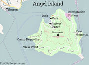
Angel Island is an island in San Francisco Bay. Originally the home of a military installation, the island now offers picturesque views of the San Francisco skyline, the Marin County Headlands and Mount Tamalpais![]() . The entire island is included within Angel Island State Park, administered by California State Parks. The island, a California Historical Landmark, has been used for a variety of purposes, including military forts, a US Public Health Service Quarantine Station, and a US Bureau of Immigration inspection and detention facility. The Angel Island Immigration Station on the northeast corner of the island, where officials detained, inspected, and examined approximately one million immigrants, has been designated a National Historic Landmark.
. The entire island is included within Angel Island State Park, administered by California State Parks. The island, a California Historical Landmark, has been used for a variety of purposes, including military forts, a US Public Health Service Quarantine Station, and a US Bureau of Immigration inspection and detention facility. The Angel Island Immigration Station on the northeast corner of the island, where officials detained, inspected, and examined approximately one million immigrants, has been designated a National Historic Landmark.

Map of Angel Island
Angel Island is the second largest island in area of the San Francisco Bay (Alameda is the largest). On a clear day, Sonoma![]() and Napa
and Napa![]() can be seen from the north side of the island; San Jose
can be seen from the north side of the island; San Jose![]() can be seen from the south side of the island. The highest point on the island, almost exactly at its center, is Mount Caroline Livermore, more commonly known as simply Mt. Livermore, at a height of 788 feet (240 m). The island is almost entirely in the city of Tiburon
can be seen from the south side of the island. The highest point on the island, almost exactly at its center, is Mount Caroline Livermore, more commonly known as simply Mt. Livermore, at a height of 788 feet (240 m). The island is almost entirely in the city of Tiburon![]() , in Marin County, although, there is a small sliver at the eastern end of it, Fort McDowell, which extends into the territory of the San Francisco. The island is separated from the mainland of Marin County by Raccoon Strait
, in Marin County, although, there is a small sliver at the eastern end of it, Fort McDowell, which extends into the territory of the San Francisco. The island is separated from the mainland of Marin County by Raccoon Strait![]() , the depth of the water approximately 90 feet. The United States Census Bureau reported a land area of 3.107 km² (1.2 sq mi) and a population of 57 people as of the 2000 census.
, the depth of the water approximately 90 feet. The United States Census Bureau reported a land area of 3.107 km² (1.2 sq mi) and a population of 57 people as of the 2000 census.
Coming soon!